Location MapClick to explore · switch to satellite inside the map
Photo
1 / 2
Floor Plan
Floor plan not available yetAsk us and we'll get it to you as soon as it's available.
Building Description
Property Overview
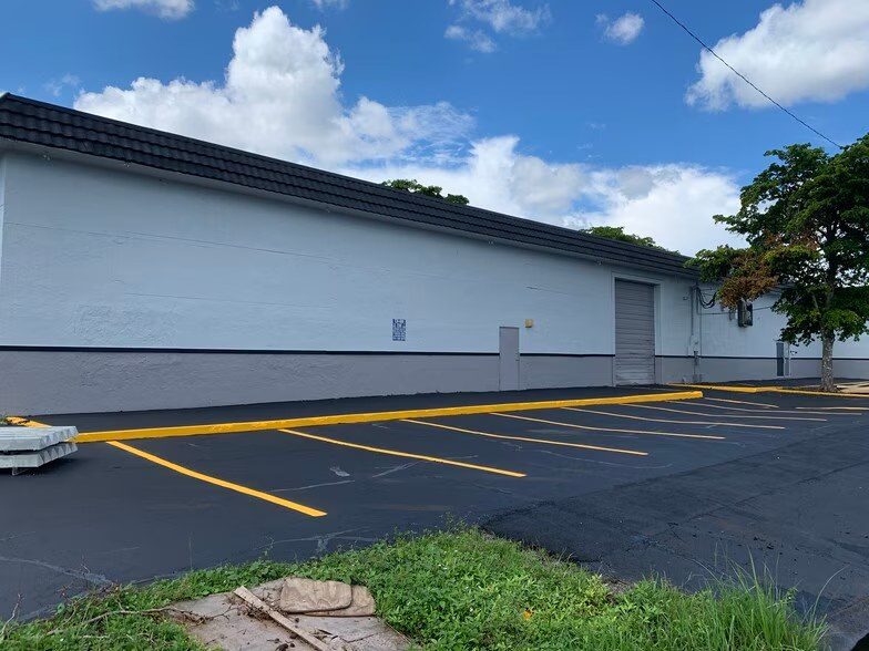
Prime 9,000 SF warehouse available for lease in Miramar. The space features 18' clear ceiling heights and a brand-new 14' high by 12' wide overhead door for easy loading. The open layout is ideal for distribution, shipping, storage, light manufacturing, or service-based businesses. Located on a corner lot with ample parking, the property offers convenient access for trucks, employees, and deliveries. A great opportunity for businesses seeking functional warehouse space in a central Broward location.
Approved Uses by Zoning — Transit Oriented Corridor District - Special (SD)
Uses permitted by right under the municipality’s zoning for this district. The property may carry additional restrictions (deed, association or lease), so tenants are responsible for confirming their intended use with the municipality and landlord before committing.
Allowed by right
Residential: Mixed Use Building, Office: Business and Professional, Office: Office Building, Office: Work-Live, Commercial: Display Gallery, Commercial: Entertainment, Commercial: Kiosk, Commercial: Open-Air Market, Commercial: Personal Service, Commercial: Restaurant, Commercial: Retail Building/Store, Civic: Bus Shelter, Civic: Conference Center, Civic: Exhibition Center, Civic: Fountain or Public Art, Civic: Library, Civic: Live Theater, Civic: Movie Theater, Civic: Museum, Civic: Outdoor Auditorium, Civic: Parking Structure, Civic: Playground, Civic: Surface Parking Lot, Civic: Religious Assembly, Civic: Fire Station, Civic: Police Station, [SD2 Open Space] Open space and passive recreational areas, [SD2 Open Space] Publicly operated camp grounds, [SD2 Open Space] Boat ramps and docks, [SD2 Open Space] Outdoor cultural, educational and civic facilities, [SD2 Open Space] Parks, [SD3 Community Facility] Parks, [SD3 Community Facility] Places of public assembly, [SD3 Community Facility] Libraries, [SD3 Community Facility] Cultural, civic and community centers, [SD3 Community Facility] Municipal government, administration, services and maintenance facilities, [SD3 Community Facility] Police and fire protection facilities
With special approval
Residential: Accessory Unit [by Administrative Approval, Sec. 715 Table 9A], Residential: Apartment Building [by Administrative Approval, Sec. 715 Table 9A], Residential: Live/Work Unit [by Administrative Approval, Sec. 715 Table 9A], Lodging/Hotel: Inn [by Administrative Approval, Sec. 715 Table 9A], Office: Medical/Dental [by Administrative Approval, Sec. 715 Table 9A], Commercial: Banks, Financial Institutions [by Administrative Approval, Sec. 715 Table 9A], Commercial: Liquor Selling Establishment [by Administrative Approval, Sec. 715 Table 9A], Commercial: Push Cart [by Administrative Approval, Sec. 715 Table 9A], Commercial: Commercial Use with Drive Through Facility [by Administrative Approval, Sec. 715 Table 9A], Commercial: Childcare Center/School [by Administrative Approval, Sec. 715 Table 9A], Commercial: Funeral Home/Mortuary [by Administrative Approval, Sec. 715 Table 9A], Other: Education: Trade School [by Administrative Approval, Sec. 715 Table 9A], [SD3 Community Facility] Governmentally sponsored/subsidized residential/care facilities for the aged and/or handicapped, nursing homes, convalescent homes, congregate care [by Administrative Approval], [SD3 Community Facility] Hospitals and clinics [by Administrative Approval], [SD3 Community Facility] Non-municipal governmental buildings [by Administrative Approval], [SD3 Community Facility] Private fraternal, civic, charitable, professional or educational non-profit organizations [by Administrative Approval]
Figures for the census tract this property sits in — the immediate surrounding neighborhood (roughly ½–2 sq. mi). For distance‑based totals, see the 1 / 3 / 5‑mile rings below.
6,345
Population
$60,865
Median Household Income
34
Median Age
1,699
Households
$274,300
Median Home Value
Household Income of 1,699 households
<$50k637 37%
$50–100k628 37%
$100–150k269 16%
$150k+165 10%
Age of 6,345 residents
Under 181,649 26%
18–341,630 26%
35–541,444 23%
55–64807 13%
65+815 13%
Trade-Area Rings · Distance from Property
Everyone living within a straight‑line radius of the property — the classic retail trade area. Each ring is cumulative (the 3‑mile total includes the 1‑mile).
1 Mile
24,473
population
7,041 households
$67,246 avg income
3 Miles
210,647
population
69,578 households
$79,165 avg income
5 Miles
520,925
population
183,902 households
$81,185 avg income
Frontage Traffic vs. Palm Beach County's Busiest Roads
This property fronts SW 60th Way. Below, its measured daily traffic (FDOT count) is compared to five of the county's busiest roads — I‑95, Florida Turnpike, Okeechobee Blvd, US‑1/Federal Hwy, and Military Trail (approximate peak AADT) — to show how much exposure the location gets.
52,500vehicles / day on SW 60th Way (AADT)
I‑95 (interstate)255,000
Florida Turnpike95,000
Okeechobee Blvd62,000
◆ SW 60th Way52,500
US‑1 / Federal Hwy46,000
Military Trail40,000
This frontage carries about 21% of I‑95's volume — strong major‑arterial exposure. County roads shown are approximate peak AADT.
FDOT count stations on SW 60th Way 52,500 AADT between SR-824/PEMBROKE RD (2025) 43,500 AADT between US-441/SR-7 and DR MLK JR BLVD (2025) 35,500 AADT between SR-7 and MLK BLVD/SW 56 ST (2025) 34,500 AADT (2025)
Risk & Incentives
🌊 Flood Zone X · minimal✓ Not in Flood HazardNot an Opportunity Zone
Street ViewClick to load · then drag to look around