Location MapClick to explore · switch to satellite inside the map
Space Description & Highlights
Tons of parking on site. High ceilings. High quality construction. Perfect condition. Etc.
Photo
1 / 2
Floor Plan
Floor plan not available yetAsk us and we'll get it to you as soon as it's available.
Building Description
Executive Summary
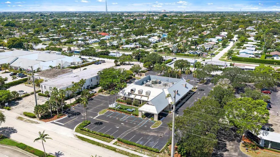
Excellent North Palm Beach Opportunity! Rare opportunity to own a piece of the thriving North Palm Beach Market. This property is located in the Heart of North Palm Beach along the US Highway #1 corridor. This is a luxury commercial building with incredible access to all parts of North Palm Beach and Palm Beach County. Close to Lost Tree, Seminole Landing, Trump National Golf Course, Bear’s Club, Admiral’s Cove, Frenchman’s Creek, Frenchman’s Reserve, Old Palm, Ballenisles, and the Atlantic Ocean. Building consists of 7,225 SF, on a site consisting of 1.66 acres. Tons of parking on site. High ceilings. High quality construction. Perfect condition. This property is currently operated as a Restaurant. With zoning and the site size there are numerous use potentials for this site. Medical, ALF, Professional use, retail, Etc. Etc.
Amenities24 Hour Access; Pylon Sign; Signage; Air Conditioning
Walk Score50/100
Approved Uses by Zoning — C-MU US-1 Mixed-Use (CA)
Uses permitted by right under the municipality’s zoning for this district. The property may carry additional restrictions (deed, association or lease), so tenants are responsible for confirming their intended use with the municipality and landlord before committing.
Allowed by right
Dwelling, all other dwelling types (i.e., other than one-family detached and mobile home park), Live/work unit, Community residential home (subject to the same requirements as apply in the R-2 zoning district), Bed-and-breakfast establishment, Hotel, Motel, Time-share unit, Offices, general, Office or clinic, medical or dental, Stores & services, general, Garage, parking, Restaurant or cocktail lounge, Church or place of assembly, Civic space, Family day care, Government building, Public space
With special approval
Assisted living facility (only as part of a mixed-use development that complies with Future Land Use Policy 1.B.3), Stores & services, large format, Dog daycare, Drive-through facility (for any use), Brewery with offsite distribution, Telecommunications antennas, Child care facility, School, public or private
Figures for the census tract this property sits in — the immediate surrounding neighborhood (roughly ½–2 sq. mi). For distance‑based totals, see the 1 / 3 / 5‑mile rings below.
3,340
Population
$82,386
Median Household Income
50
Median Age
1,473
Households
$385,700
Median Home Value
Household Income of 1,473 households
<$50k394 27%
$50–100k406 28%
$100–150k312 21%
$150k+361 25%
Age of 3,340 residents
Under 18512 15%
18–34513 15%
35–54910 27%
55–64691 21%
65+714 21%
Trade-Area Rings · Distance from Property
Everyone living within a straight‑line radius of the property — the classic retail trade area. Each ring is cumulative (the 3‑mile total includes the 1‑mile).
1 Mile
8,817
population
4,117 households
$120,352 avg income
3 Miles
68,506
population
28,788 households
$112,970 avg income
5 Miles
140,733
population
57,809 households
$128,092 avg income
Frontage Traffic vs. Palm Beach County's Busiest Roads
This property fronts US Highway 1. Below, its measured daily traffic (FDOT count) is compared to five of the county's busiest roads — I‑95, Florida Turnpike, Okeechobee Blvd, US‑1/Federal Hwy, and Military Trail (approximate peak AADT) — to show how much exposure the location gets.
20,400vehicles / day on US Highway 1 (AADT)
I‑95 (interstate)255,000
Florida Turnpike95,000
Okeechobee Blvd62,000
US‑1 / Federal Hwy46,000
Military Trail40,000
◆ US Highway 120,400
This frontage carries about 8% of I‑95's volume — lighter neighborhood traffic. County roads shown are approximate peak AADT.
FDOT count stations on US Highway 1 20,400 AADT between SHORE CT (2025) 8,600 AADT between ALT A1A and SR-5/US-1 (2025)
Risk & Incentives
🌊 Flood Zone X · minimal✓ Not in Flood HazardNot an Opportunity Zone
Street ViewClick to load · then drag to look around